I'm still a little gun-shy since the city of Jonesboro keeps missing the snow/sleet/freezing rain. There has not been ANY wintry weather in the city, despite some place in our viewing getting a little here and there.
Let's dig right in with the snowfall analysis from good ole Earl Barker's website. It gives you a nice little summary of what each model is thinking. This is probably the most amazing and hopeful data so far. This is the snowfall estimate from the NAM using the Kuchera algorithm. It shows over 7" in some areas!!! Whoa.... I don't buy that... yet... moving along...
 The next image is the GFS snowfall estimate. Once again, it shows snow in Region 8, but a lot of it stays out of Jonesboro. The GFS is being a little more conservative with 1-4". With each model run, the GFS is starting to look more and more like the NAM.
 Below is the precipitation on Thursday evening on the GFS. The rain/snow line would be hovering in Region 8, with substantial moisture around. Some nice snow would be falling in parts of Region 8, especially in the Ozarks.
 Here's the more robust NAM which shows heavy snow across parts of the area. The NAM is a little colder and a little wetter (snowier) than the GFS.
 Below is the NAM in the overview window on BUFKIT. The time goes from right to left. You can see the rain on Tuesday and then Thursday's storm. If this verified, we would start with some rain and then quickly switch to snow with significant accumulations.
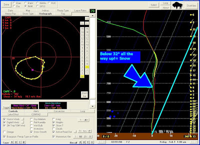
 Let's dig a little deeper and look at the skewT forecast sounding for 2:00 AM on Friday morning. This would be the perfect snow setup!
 The temp/dewpoint are side-by-side up to 500 mb, which indicates a saturated atmosphere. As you can see below, the temperature stays at or below freezing all of the way up. IF this verified, we would have heavy snow falling in the middle of the night.
 Nighttime snow is SOOO much better than daytime snow. It sticks better and accumulates faster. I want snow just as much as many of you, but we DO NOT NEED TO GET EXCITED YET!
This is still a few days out and things WILL change. Keep it tuned to the Region 8 Storm TEAM and we'll give you the latest data.
I was a little conservative on the TV tonight, but I may ramp it up tomorrow on-air...
Have a great week!
Ryan
5 comments:
I won't get my hopes up until that strong low kicks on out tomorrow afternoon. I do want to thank you Ryan for changing the track of the low and at least giving us a chance.
Last year didn't we get our first good snow on the 31st ? :-0
What a front coming in this afternoon!
So, you're rolling out the Earl Barker on us!
This is NOT GOOD ... and by that I mean, my reading this is coinciding with my morning coffee being half gone! =-O
... This AFTER I just watched your helium video!
You may need that abominable snowman afterall! :D
I hope you get some snow! I'll keep my fingers crossed. When you do, you can send more down our way, (Prattville). :)
Have a great day!!
Your Weather-Fu is impressive and way over my head.
I will stay tuned.
Good Afternoon Ryan,
I don't think we will get any SNOW. It seems that everytime some Wintry Precipitation has been predicted for us, it all went around us. So, I'm saying we won't get anything. Oh, we may see a flake or two, but I just don't see us getting anything. We have certainly received alot of Rain here in Caraway this morning. I don't mean a slow and steady rain, but some heavy blowing rains. I am guessing we have received around 3 inches or better here this morning. Now, we are under a Tornado Watch. I sure hope that goes on around us. I don't like Tornado Weather. Take care my friend and have a great day. May God Bless You and Yours.
Karen Horton
Caraway, AR
Post a Comment