When forecasting severe weather, I "kind of" have a checklist I go through. First, I simply check the thoughts of the SPC (Storm Prediction Center). They are some smart folks and worthy to listen to for severe wx. Are we in a risk according to them? Yes. Are we in a slight, moderate, or high risk? Yes, slight. Second, I start digging into the data to see if I agree with them. Here's their convective (thunderstorm) outlook for tomorrow:
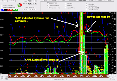
Today, I'm looking at tomorrow afternoon and evening for severe wx. I'm wanting to look at the low-level moisture, upper-level flow, mid-level flow, instabilty, and lift. After going through my checklist, I believe we will see some severe weather tomorrow afternoon and/or evening. Let me show you why. First, the overview of the 6Z GFS:
If you click on the image, you'll see it shows dewpoints near 60°. I like to see 55°+ to support severe storms (although severe wx can occur with lower DPs). You'll see indictions of "lift" which supports the storms to grow or "bubble up" as my boys say. You'll also see the spike in CAPE or Convective Available Potential Energy. This is the energy for the storms. So, one by one, I'm checking off my list... Let's look at the winds now. First, let's check the 850mb winds:
My threshold (or flag) to look for here are winds 35kts or greater. Long line=10 kts, short line= 5kts, and a "triangle"=50 kts. As you can see, the GFS is showing 35 kts at about 5,000 feet tomorrow. Check. Now let's go UP in the atmosphere to 500 mb:
On this map, I'm looking for winds to be "spreading out" or diffluent. Notice how the lines fan out or seperate. That's the air spreading out, creating somewhat of a void for rising air and thunderstorms. Once again, signs of convection/thunderstorms.
There are a few more things I look at, but I don't want to bore you to death... just be prepared. We'll be in constant contact with the NWS for warnings and information and in contact with area storm spotters. Look at my Twitter updates on the right side of the page for instant updates.
While we have several signs pointing to severe weather, it's still not certain. I've seen all signs point to severe weather and nothing happens, but we need to be on guard. Our last decent round of severe weather (tornadoes/hail/winds) was in July.
Be weather aware!
Ryan


3 comments:
after seeing this afternoons 18z nam i am growing quite concered 0-3ehi's aoa 3- which is at 3z geeze- last thing we need is nocturnal tornadoes
I love the technical maps and explanations behind the forecasts that you post! Very interesting to learn...Thanks for taking the time!
ugghh not looking forward to this weather at all. Some rain is fine but lightning, Thunder and high winds plus bad downpours can stay away!
Post a Comment