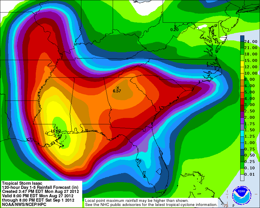
Some people were joking about me tracking Isaac when it was out in the Atlantic, but as we learned with Ike a few years back.... we must watch the Tropics in Region 8. There are still a lot of questions with the path, but if it takes the path from the Hurricane Center issued at 4PM, we could see some substantial rain. Here is the CURRENT forecast from the Hydrological Prediction Center:
First, notice that parts of Southern Mississippi could get over 16" of rain!!! IF it takes the path on the NOAA forecast, we could see over 5" of rainfall! That would wipe out about 40% of our deficit. In addition to heavy rain, we could see some wind. 20-30 mph winds would be possible. Here's a map we will watch closely. Clearly, the PROBABILITY of seeing Tropical Storm winds goes down with time. You won't see 75-100% chances of TS winds 5 days out. Make sense? As it gets closer, our chances could go up:
Lastly, we started running a 20km resolution grid on StormCAST over Isaac's path last week. Here is what it shows right now for Wednesday at 8PM. It only goes out 48 hours. Once again, we'll watch this closely:
I'm off work tonight, but Bryan is watching it closely! Tune in tomorrow morning with Sarah Tipton for the latest information. We could easily be dealing with rain and wind later this week!
Ryan


1 comment:
Love that you keep us so closley posted on any weather period. Keep up the good work. You have us spoiled you know.
Post a Comment