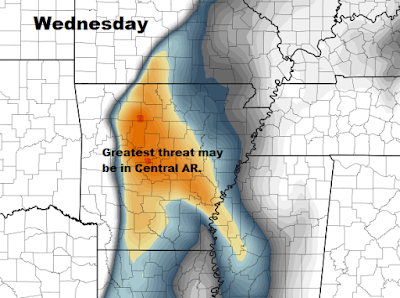
- Severe weather is possible on Wednesday. At this time, it appears the greatest threat will be in Central Arkansas, but we need to watch that carefully. All threats are possible: hail, strong winds, and tornadoes.
- We get a break for Thursday and most of Friday.
- Friday night, severe threat increases.
- Saturday, severe weather is possible. Storms come in waves.
- Sunday has the most dynamics. By that, I mean the winds at the surface and aloft are favorable for severe weather. Low passes north and the threat ends by Sunday night.
- River flooding will be a concern, especially on the Black River that is already at minor flood stage. A lot of rain may fall north of the Black River basin.
Now, let's dig into some details and I'll try to keep this as simple as possible. Below is a graph showing the expected rainfall from each chance of storms. Notice that we could easily end up with over 3" of rain over the next 7 days. Some parts of northern and western Region 8 could have 4-5". This graph is for Jonesboro:
Wednesday is the first day we are going to watch. The greatest threat may be in the central part of Arkansas, but we need to watch it closely. Below is a map showing EHI (Energy Helicity Index). It shows us where the greatest threat of COMBINED energy and shear are located. This is Wednesday evening:
After Wednesday, drier air and high pressure moves into the area. Below is a graph showing dewpoints (measure of moisture in the air). I've placed the cold fronts and the warm front to show you when the moisture increases and decreases. Notice the drop on Thursday. Thursday will be nice:
I'm going to try to make this as simple as possible.
Friday will be interesting because we have very high CAPE (energy for storms), but may have conditions in place that block thunderstorm development. Warm front lifts north and everyone south of the front will be unstable. What this means is that the coverage may not be that widespread, but anything that forms will likely be severe. It's call a conditional threat:
Saturday is similar in nature as a few pieces of energy move through the atmosphere, we may see severe weather:
Sunday, the low pressures dig into the region and the atmosphere really gets rowdy. The wind direction and wind speed will change with height. The wind shear will be high. In my opinion, this may be the day with the greatest severe weather threat, but we shall wait and see:
The front comes through Sunday night and the threat ends.
All of this can change, but those are my quick thoughts on this Monday morning while I sip coffee. I tried to make that as simple as possible, Just stay weather aware over the next week,
Ryan


2 comments:
Thank you for the heads up!!
Ryan, you make weather very interesting and the way you explain things make it easy to understand. THANK YOU. I wish I could pick up KAIT8 on Dish.
Post a Comment