Sunday, February 06, 2022

Halfway Through Winter Update


 We are about halfway through winter and I wanted to look back at my winter outlook to see how we are doing so far. Unfortunately, I'm giving myself a C right now. It's passing, but it's not great. I BLEW the December outlook, but several of the other bullet points are happening. At the start of January, my grade was a big fat F. So, here's what I had as the Winter Outlook for 2021-2022 with my grade so far:
  • FAIL: Big arctic outbreaks are possible in December. Overnight lows in the teens are likely and single-digit lows are possible
  • PASS: Sleet and freezing rain is more likely than snow this winter.
  • HALF CREDIT SO FAR: 1 decent snow event. 2-3 sleet and freezing rain events.
  • PARTIAL CREDIT: Flooding rains are possible, especially in February. Magnitude is still questionable, but seeing 5-6" of rainfall in February is not out of the question.
  • GRADE NOT IN YET: February will have above average temperatures.
  • PASS: Big swings in temperatures are likely through the winter.
  • PASS: 1-2 Severe weather events are possible with damaging winds. Maybe even tornadoes.
Let's recap... I wrote this outlook in November. I started at the beginning of the month and finished up after Thanksgiving. Doing an 8-Day Forecast is tough enough, so I'm not sure why I do a 3 month outlook. I suppose it is fun and I enjoy the research. First off, my outlook for December was WAY off. It was the worst monthly outlook I've ever written. I predicted below average temperatures with big arctic outbreaks and we had the warmest December on record! This is why I had a big fat F at the end of the month. 

Since then, a lot of the outlook is verifying true. We have had more sleet and freezing rain than snow. We have had 2-3 "icy" events. I'm giving myself partial credit on the possible flooding rains. We had some heavy rains in December, but not to the magnitude I thought and I also thought that would be more likely in February. We will watch to see how the rest of the month pays out. We will also have to see if we have above average temperatures in February. It's hard to imagine right now, but we do have above average temperatures in the forecast. The last two items have happened. We have had big swings in the temperatures and we have had severe weather. One of those severe weather events (Dec 10) was one of the worst ones we've ever had in Region 8. 

So for now, I'm giving myself a C. It's not great. It's passing and there is no chance of me getting an A this semester, BUT if we have above average temperatures, some heavy rain, and one good snowfall this month, I'll bring it up to a B. Honestly, I could do without the heavy rain and snow... so I hope I end up with a C+ of B-. :)

Saturday, November 27, 2021

Winter Forecast 2021/2022


94-year-old Donald Waterworth has been taking weather observation in Pocahontas for decades. As I was researching similar winters of the past, I came across some of his weather logs. I was happy to hear that he is still recording the weather conditions for Pocahontas today! He's a huge asset to Region 8 weather and his work will go on forever! According to the National Weather Service, the Pocahontas weather station is one of the longest running weather stations in the state! I'll have to ask Mr. Waterworth one day when he took over the reports. The National Weather Service in Little Rock has the first report from Pocahontas 1871! Here it is:


The reason I was looking through the old Pocahontas weather logs was to look back at the 2000/2001 and 2008/2009 winters. As some of you know, I look back at the winters that had similar patterns to what we have now in order to forecast the upcoming season. With the exception of a couple of years, this technique has worked really well for me in the past! So, with that said, let's look back at the winter of 2000/2001 in Pocahontas. The highlighted areas are just random things I noted while researching. First, let's look at December of 2000 in Pocahontas:
The first thing I noticed about December of 2020 is that there was some COLD air! We had some overnight lows in the single digits and several nights in the teens! There was also a 2" snowfall recorded by Mr. Waterworth on December 13th. To compare what was happening across all of Region 8, I also pulled the climate log from Jonesboro that month:

A couple of notes from the Jonesboro log show that while it was snowing in Pocahontas, it was ICE in Jonesboro. In fact, the weather observer made a notation that they could not drive home on the ice! Notice in both Pocahontas and Jonesboro, there was also a little 1" snow at the end of the month that stuck around for awhile because it was so cold!

Now, let's take a quick look at January of 2001. In both Pocahontas and Jonesboro, the year started VERY cold and we had some some small wintry events through the month. First, here's Pocahontas:
And now Jonesboro, January 2001: 
The most notable thing in February was heavy rain. Temperatures started to rebound, but we had some heavy rain. Notice, almost 4" of rain fell in 48 hours in Pocahontas:

And in Jonesboro, you can see the heavy rain fell and the observer noted that there was "flooding":
For fun, I also pulled the climate log from Black Rock in February of 2001 to get the reports about the Black River. With the heavy rain, the Black River rose to over 18' there, which is just some minor flooding:

The 2000/2001 season was just one of the seasons I thought had similarities to our upcoming season. It also looks like 2008/2009 winter might have some similarities. Now, some of you just *gasped* because you instantly thought about the 2009 Ice Storm. Please remember that we are only talking about similarities in patterns, not absolutes! 

While looking back at the 2008/2009 Winter, I see really cold air and little wintry events in December, just like the 2000/2001 Winter. I see the historic ice storm at the end of January, which most of us recall. Lastly, I see a big rainfall in the middle of February. Something else to note is a big snow at the end of the month in Pocahontas, but none in Jonesboro. I think I remember that one, too. Here's the climate logs from Jonesboro's 2008/2009 winter:


So, what's going to happen in Winter 2021/2022? After looking at all of this data (and much more), here are my bullet points for the Winter of 2021/2022:
  • Big arctic outbreaks are possible in December. Overnight lows in the teens are likely and single-digit lows are possible
  • Sleet and freezing rain is more likely than snow this winter. 
  • 1 decent snow event. 2-3 sleet and freezing rain events.
  • Flooding rains are possible, especially in February. Magnitude is still questionable, but seeing 5-6" of rainfall in February is not out of the question.
  • February will have above average temperatures. 
  • Big swings in temperatures are likely through the winter.
  • 1-2 Severe weather events are possible with damaging winds. Maybe even tornadoes.
Now, we sit back and watch! Don't get too worried about the ice threat. Even if we had the same magnitude ice storm of 2009, our infrastructure is so much better these days. I honestly don't think we will see an impact like the 2009 ice storm for decades due to trimmed trees and a stronger electric grid. 

Enjoy!


Wednesday, March 31, 2021

20 Years Ago I Started at KAIT

    Officially, I started at KAIT 20 years ago today. There seems to be some confusion on *when* I started because the official documents say today, but my memory has my first day being March 27th. Regardless, I'm 100% sure my first day ON AIR at KAIT was April 3, 2001. I know this for two reasons. First, it was my birthday. Second, it was for a tornado warning in Cross County. Whew, my coverage was horrible. I stumbled all over the place and I called Wynne.... WINE. At least, I was much skinnier and had more hair.

Anywho, It was a Tuesday night. I had watched Mark Frankum do the 5:00 and 6:00 news and we were in the Storm Center going over several things regarding my new job. A tornado warning was issued at 7:47 PM for Cross County. A storm with rotation was coming out of Jackson County and moving into Cross County. Mark surprisingly handed me a mic, I put in my earpiece, and stumbled through the coverage. When I mispronounced Wynne as "wine", a voice comes in my ear and says "Wyyyyyne"... All confidence was gone for the rest of the warning!  If you notice, this was when a tornado warning included the entire county instead of a polygon:

The storm continued moving south and the warning was expanded to include St. Francis county, too. 

Thankfully a tornado never touched down! Also, thankfully I learned how to say "Wynne". Coincidentally, I was in Wynne for their tornado warning last Saturday night, which I still believe was my real 20 year anniversary of working with this company. 

Side note: I did transfer to another one of our stations for a little over 2 years. I loved my brief time in Alabama, but LOVE that we made Region 8 our home to raise our kids. 

Have a great night!
Ryan

Tuesday, November 17, 2020

WINTER OUTLOOK: 2020-2021


I was almost scared to make a prediction in 2020 regarding the winter! We are all preparing for the worst in our minds, but let's take a deep breath and look at some data! First off, this is just an outlook. While I've had many successful winter forecasts, I've also had a couple of BUSTS. Thankfully, I still have a winning record. Regardless, I always like to remind everyone that I do these outlooks for fun and I don't expect anyone to make critical decisions based on this outlook.

As you may have heard, we are transitioning from a weak El Nino pattern to a La Nina pattern. This pattern is determined by the sea surface temperatures in the equatorial Pacific Ocean region. As with all of my outlooks, I like to look at global patterns and compare them to the past. While we can't look at the past and get definitive answers, we can get an idea of what we saw in Region 8 when we had similar setups.

After looking over the data, I decided to look at TWO winter seasons to derive an outlook for Region 8 for the 2020-2021 winter season: The winter of 1955-1956 and the winter of 1995-1996. The 1955-1956 climate logs were kept by the Benedictine Sisters of the Holy Angels Convent. For those that don't know, the Holy Angels Convent is located on KAIT road and is only a mile from the TV station. The 1995-1996 climate logs were kept by my predecessor, Terry Wood at KAIT.

First, here are the climate logs from December 1955-February 1956:
As you can see in the above image, December of 1955 had some big swings in temperatures and some flurries. A couple of mornings started in the TEENS, while some days had highs in the 60s and 70s! Big swings like that indicate an amplified pattern. I'm a little surprised we did not have more severe weather.
The above log shows January of 1956. Snow lovers will love this month. We had TWO decent snowfalls. The first was a 5" snowfall on the 18-19th. Not all of the snow had melted when another 1.5" fell on the 23rd-24th. Some sleet was mixed in, as noted in the comments. Once again, we see HUGE swings in temperatures. Notice how it was 17° on the 24th, but 67° a few days later on the 28th! Wow. 

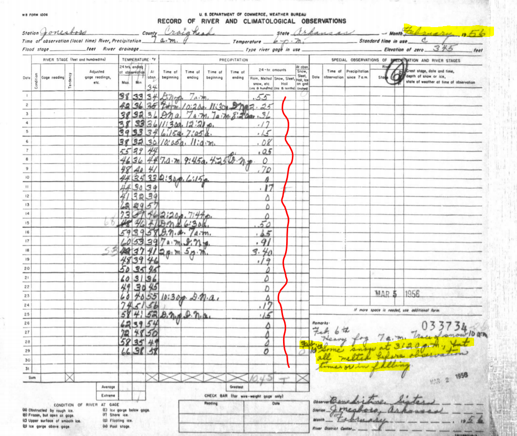
The above image is the log from February of 1956. This was not a good month for snow lovers. While a few flakes flew on February 10th, the comments show that it melted quickly. Temperatures moderated a lot this month. No teens. Not many 20s. And many days were in the 50s, 60s, and 70s! This is something worth noting! Also, we had severe weather, including tornados. Here are the tornadoes that occurred in February of 1956:


So, now let's take a look at the Winter of 1995-1996:

The above image is the climate log from December of 1995 from Terry Wood. The first thing that jumps out at me is the big swings in temperatures again! We had a couple of mornings in the TEENS, including 14° on the 16th. Yet, on Christmas Eve, it was 74°! That's wild!


Let's look at January of 1996:

January of 1996 was WILD. At face value, there was only 2" of snow or less. BUT, let's dig deeper. Take a look at January 18th. The high was 64° and the low was 16°! The next morning is was 8°! In the comments, Terry notes that the wind chill was -30°!, but it's worth noting that the formula to calculate the wind chill changed in 2001. Still... IT WAS COLD!


Those big swings in temperatures also led to some severe weather. There were some tornadoes in January of 1996:


Let's look at February 1996:
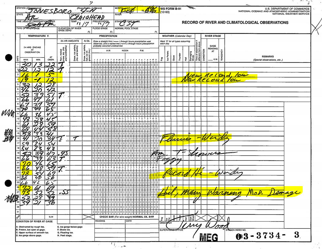
More BIG SWINGS in temperatures for February of 1996. On the morning of the 3rd and 4th, we broke record lows with 1° and -1°, respectively. In less than a week, we were back into the 60s and 70s! By the end of the month, we were breaking high temperature records with severe weather. ON the 23rd, we almost hit 80°... IN FEBRUARY.


The Spring of 1996 that followed this winter was a busy one! Here are the tornadoes from March of 1996, which includes the long-track F3 tornado that went through Izard, Sharp, and Lawrence counties:
April of 1996 was also active. We had a few more tornadoes, including a long-track F4 tornado that went through Stone and Izard counties. This tornado killed 7 people:

So, after looking over our current pattern and looking at what this pattern has done in the past, I've come up with 8 thoughts about the 2020-2021 Winter Season:


  • The Winter starts early. Very cold air comes in for December
  • Big swings in temperatures! Some mornings in the teens or single digits. Days later, much milder.
  • We will challenge record lows and record highs.
  • We will see 2-3 severe weather events with tornadoes possible.
  • We will see 2-3 winter weather events.
  • Wintry weather will likely include some sleet and freezing rain (glaze). Nothing like 2009 though.
  • We will have some very windy days!
  • We will see winter end early with a warm February, leading to an above average severe storm season in the Spring.
So there it is! Stay tuned!
Ryan

Tuesday, April 07, 2020

Severe Hail Threat: 4/8/2020

I know that I don't blog as much these days with the greater reach being on our app and social media, but I wanted to ease some fears about the severe weather threat for Wednesday night.  Severe weather is going to cause higher anxiety in the months and possibly years to come. We are forecasting a MEDIUM risk of severe weather tomorrow and we are mainly going MEDIUM because of HAIL. We can't ever rule out tornadoes, but our main worry is HAIL.  Bullet points about tomorrow:

  • Small chance of rain during the day.
  • Main threat is after the sun goes down.
  • Some data has the storms hitting as late as midnight. 
  • HAIL is the main threat. Highs winds and lightning are also a threat.
  • While the threat is not zero, the tornado threat is the lowest threat.
Stay weather aware and we will do out best to keep you updated. 

Ryan

Monday, February 24, 2020

Severe Weather Possible This Afternoon (2/24/2020)

We have a brief window of opportunity to see severe weather later today. Small hail will be the main threat, but large hail, gusty winds, and even a tornado is possible. Here are my bullet points and main takeaways:

  • Greatest risk is mid-afternoon. 
  • I'm expecting numerous "pea-sized hail" reports from these storms.
  • Gusty winds are possible.
  • 1-2 small, spin-up, fast-forming tornadoes will be possible.
  • School officials need to look at the weather situation before dismissing. Don't panic or change plans right now... just make sure there are no active warnings. 
  • Threat should be gone this evening.
Now let's talk about the details. As I type this, we are in the 40s. Temperatures are expected to warm into the 60s as a warm front continues to move north:
When we get between the warm front and the cold front, we will be in what we call the "warm sector". This is the area of concern where we will get unstable. This map below shows the instability. The parameter is called CAPE or Convective Available Potential Energy. Think of it as the fuel for severe weather. This map is just a snapshot from 3PM, so the threat will be moving west to east. Notice how it increases this afternoon:
When you breakdown more of the parameters, there are some products that try to pinpoint the risks. This map is a supercell index. Notice what it shows at 3PM. It's not crazy high, but worth bringing some concern. It could be much much worse.:
But, what most of you will be looking at is RADAR. This is a model projection of what radar could look like this afternoon. Remember, it is a model. Don't look at particular locations to pinpoint the supercells. Look at the pattern, the timing, the spacing, etc. A model is just giving you "an idea" of what could happen. It's not a prophet:
Stay weather aware this afternoon in case you get a warning at your location. Once again, this is a LOW risk.

Ryan

Tuesday, November 26, 2019

Severe Threat This Evening (Tuesday November 26, 2019)

As you can see in the above image, we have a MEDIUM risk of severe weather for this evening. Here are the bullet points, as of right now:
  • TIMING: 5PM-Midnight
  • High wind is the main threat.
  • Isolated tornadoes are possible. They would be quick and fast, if they develop.
  • Might see TWO rounds.
  • Concerned about people traveling and people at basketball games.
  • I am NOT saying to cancel anything. I just want people to stay informed.
  • Ways to stay in formed:
    • Region 8 app: Have notifications ON, Correct Warnings ON, Location services ON.
    • TV: We will have constant updates on the bottom of the screen. We will be on air if any tornado warnings are issued OR damage starts being reported.
    • Weather Radio: Test to make sure it works before the storms.
Let's look at  little bit of data. This is what round 1 could look like. These storms would have decent dynamics and instability to work with. High wind aloft could be transported to the ground within storms:
The next round comes in between 9-12. I initially thought that this round would not have the instability or "energy" to cause problems. The latest data says otherwise. This map below shows the "energy" with the second round. 
A second line of individual cells may develop with a ton of energy and dynamics to work with, so let's not let our guard down after the first round of storms.

Stay informed on the latest information with our app through the day. We'll have you covered.

Ryan

Wednesday, November 20, 2019

How Much Rain?: November 21-22

As we have been mentioning for several days, we will see rain on Thursday and Friday. Here are my bullet points on this storm:
  • No severe weather from this storm.
  • 1-2" of rainfall likely.
  • Most of the rain falls Thursday night into Friday morning.
  • Breezy both days, 20-25 mph gusts.
  • Gone by Saturday and Sunday.
So, the main question I have been getting from people is, "how much rain will we get?" Generally, the models have been showing 1-2", but some models have occasionally shown more and some  have shown less. Here's a graph showing a couple of runs on 2 of the models: 
All models are showing a swath of higher rainfall amounts across parts of Region 8 and they are in pretty good agreement on it's location. Take a look at this agreement:


Needless to say, we are confident in the rain. Pinpointing the EXACT location of the heaviest rain is the challenge. Keep an umbrella handy!

Ryan


Sunday, November 10, 2019

UPDATE: Monday's Rain To Snow

Milk and bread are still safe, but I've nudged the PANICOMETER up a little. If you are going out Monday evening, I would allow a little extra time. While most of this storm system will be RAIN, there will be a brief changeover to a wintry mix and snow on Monday evening. Keep in mind, I would suggest to allow extra time even if it just stayed rain! Here are bullet points this evening:

  • Most of tomorrow will be plain ole rain.
  • Rain will start by lunchtime.
  • It will end as wintry mix Monday evening.
  • Any accumulations will be LIGHT: decks, grills, patio furniture. (DUSTING)
  • Ends by 10-11 PM.
  • No watches, warnings, or advisories right now.
  • I would not be surprised to see some advisories as this unfolds.
  • Missouri counties stand the best chance of getting accumulations.
  • I'm telling my kids that they are going to school on Tuesday! They hope I'm wrong. LOL

Many locations will not see much accumulation and those that do will likely only have them on surfaces that are elevated. For example: decks, grills, patio furniture, and MAYBE grass. It would be pretty tough to get it to accumulate on roads.

Here's what to expect radar and temperatures to look like around 2PM. Most of us are rain, but a chilly rain:
By 6PM, the colder air starts to mix some sleet and snow into the rain in spots. But, look at the temperatures. It's tough for anything to stick when you're above freezing:
Here's one models output on snowfall potential. This is the European model:
Overall, a dusting is POSSIBLE, but not all will get it. 

Stay tuned! I'll have new data, tonight on Region 8 News. 

Friday, November 08, 2019

Snow looking LESS likely on Monday...

Monday is not looking like a big deal, even if we see a few flurries or brief light snow on the tail end of the rain. I kept telling people not to get too excited. This is also why we kept the Panicometer at the lowest level. It's just not the type of setup that yields much snow. BUT, we are still expecting a a few snowflakes.

It just doesn't look like the cold air will catch up to the moisture:
Sure, we are going to see SOME snowflakes, which is always crazy in November, but no problems are expected on the roads. It is still going to be BRUTALLY cold next! Lows will drop into the low to mid 20s again. Get ready for that.

Also, bundle up tonight for football!

Ryan

Thursday, November 07, 2019

OK... Let's chat about Monday.

Image may contain: text


At this time, the Panicometer is as low as it gets for Monday! Side note... the Panicometer is a teenager! I started the Panicometer in November of 2006. Today, stations across the nation use a similar graphic. I don't mind though. I think it is a fun way to communicate the impacts of a winter event. While it is low right now, there is a good chance that it gets nudged up a little in the next couple of days. In fact, we may nudge it up a little on Region 8 News tonight.

So, is it going to snow? Well... the easy answer is, "it might". Here are bullet points on this storm that is still 4-5 days out:
  • There will be precipitation. It may just be rain, but something will fall on Monday!
  • If the cold air plunges in, we may switch to snow.
  • The cold air IS COMING. But, will it be here before the moisture is gone?
  • LIGHT accumulations are POSSIBLE. NOT likely. So don't freak out yet.
  • Too early for an "Accumulation Forecast", but I will show you some model output below.
  • At this time, teachers and students should plan on being at school on Tuesday.
  • Keep checking back as this storm evolves. These bullet points will be adjusted.

So... let's talk about the data. We have some energy in the coming in from the SW that will enhance the precipitation while a strong cold front dives south with some brutally cold air. MOST of the event will be PLAIN OLE RAIN. As you can see in the map below, PLAIN RAIN will cover Region 8 at the start of this system: 
As we go farther into Monday evening, the MUCH colder air arrives and the models have us switching to snow. The GFS model has us switching to snow sooner in Region 8, but the Euro has the changeover after sunset. Regardless, both are showing a switch to snow:
So, how much? In years past would not even entertain that question, but in a day where you can search around on the internet and find someone sharing it anyways, I'll open that can of worms. Keep in mind that when it comes to snow "sticking", a lot of factors come into play. This is just model output. First, the Euro has the changeover later for Region 8, but has the cold air in Missouri early enough to tap into the tail end of the precipitation better:
The GFS model has the cold air coming in faster, but the precipitation ending faster, too. This really limits the snow in Missouri, but not a huge change for us in Region 8, except that the snow would come in the daytime hours. This would be good for roads. Snow sticks to roads easier at night for several reasons. Anywho, here's the GFS:
Once again, those are just maps of model output. Being that it is still a few days out, this could change a lot! Stay tuned!

Ryan