- Friday looks fine. Outside of a few pockets of showers or sleet, Friday is not concerning.
- Saturday is the main day.
- All modes of precipitation are possible: Rain, sleet, snow, and freezing rain.
- Travel impacts are becoming likely for areas NW of Highway 67. Possible for areas SE of Highway 67.
- It's still too early to nail down accumulations with accuracy.
When we are 4 days out, it's typically the time to start focusing in on making alternative plans. I do think this storm will impact a large part of Region 8. I do think we will have some travel issues. A lot of the precipitation will be falling during the daytime hours on Saturday, so that may help the roads stay a little more clear. Time will tell.
Let's dive into some maps. First, let me show you the GFS model. This 4-panel shows how much of each precipitation type may fall. My biggest worry right now is that we get more freezing rain (ice glaze) than snow. Now, before anyone says it... NO, not 2009 bad. But, freezing rain is never good. It typically does not mess up the roads too bad, but can be bad for trees and power outages:

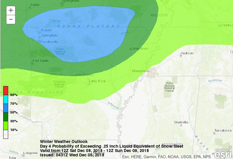
Since we are 4 days out, the Weather Prediction Center does not breakdown precipitation type in their probabilities yet, but they are indicating a good chance of wintry weather across Region 8 on Saturday. This map shows the probability of 0.25" liquid equivalent of winter precip on Saturday. This is... if you melted down whatever fell to liquid. For example... 0.25" is roughly 2-3" of snow:
If you breakdown what the GFS is saying for just snow, here is the model output. This matches up well with what we have been showing on air, too:

Now, let's talk about the oddball of the data. This morning, the NAM models comes in and goes bonkers for snow and ice for a large parts of the state. By 6PM on Saturday, look what it shows... with much more to come (look west):

In summary, something is going to happen on Saturday. We will have a much better grasp on the details tomorrow morning.
Stay tuned!
Ryan
No comments:
Post a Comment