 What's everyone think about the new radar display system we have here at WSFA? When we first got the system there were a few network issues that we have now ironed out now. We still are only using it only during severe weather events. We're still tweaking the system, but it did quite well with the hail storms on Wednesday. Rob and I held down the storm center during the event on Wednesday. Hopefully everyone got the information they needed. We didn't have any tornado reports, so that is always good. Sentinel SP never flagged any of the storms as being tornadic, so we didn't have any false alarms. The rotating symbol you see above indicates a "mesocyclone". If Sentinel SP had indicated a tornado, it would actually put a little tornado symbol. Hopefully we will not see too many of them! The symbol below of indicates where hail is falling, and with Wednesday's event... we had golfball sized hail! eek!
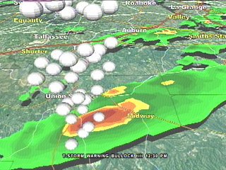 So what are you thoughts about this new equipment? Is it good or bad?... too technical?... too cartoony?... don't care?....Love it? Drop me an email at rvaughan@wsfa.com
AMS definition of mesoscyclone-The vorticity associated with a mesocyclone is often on the order of 10−2 s−1 or greater. (It should be noted that a mesocyclone is not just any cyclone on the mesoscale; it refers specifically to cyclones within convective storms.) Mesocyclones are frequently found in conjunction with updrafts in supercells. Tornadoes sometimes form in mesocyclones. Persistent mesocyclones that have significant vertical extent are detected by Doppler radar as mesocyclone signatures. Tornado warnings may be issued when a mesocyclone signature is detected.
No comments:
Post a Comment