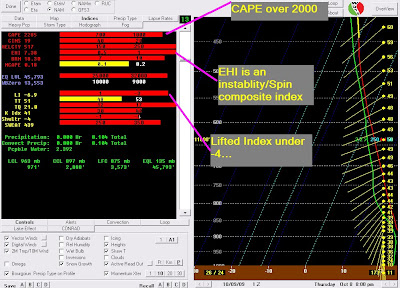
Below is a nerdy weather program we use called BUFKIT. This is the morning run of the NAM model. A few things to note for this evening... First, CAPE is over 2000. Anything over 1500 would concern me today. EHI is a combination index of shear and instability. Anything over 2-3 would concern me today and it is up to 7. Finally, the old classic "Lifted Index" is down to -6 or-7... anything under -3 or -4 is a red flag. IF, and I did say IF this happened... severe weather would be likely. We'll continue to watch everything unfold and I will update my Twitter feed on the right side of my blog...
 Before I sign off, SPC has issued their new outlook. 10% chance of tornadoes has been noted in Region 8. That may not seem that high, but it is when referring to a tornado threat! The blue "hatched" area is a 10% or greater probability of tornadoes EF2 or greater from 25 miles of any given point. That's comforting, right?
 I'll be updating Twitter through the day unless we have to go on air.
Stay tuned,
Ryan
PS-Sun just peaked out at my house!
7 comments:
Dewpoint is up to 66 here; still brightening up but no sun peaking through yet.
The Sun is shining here in Caraway, AR. I'm showing 81 degrees right now on my Computer as well. Doesn't appear to be a good combo if you ask me. Also, it's very windy outside.
Karen Horton
Caraway, AR
Would you post the link to NAM data that you use for the BUFKIT? The only NAM data I can find is over a day old.
http://www.meteo.psu.edu/bufkit/CONUS_NAM_12.html
Where do I find rainfall totals?
Where can I find rainfall totals?
Sorry, first time user.
Post a Comment