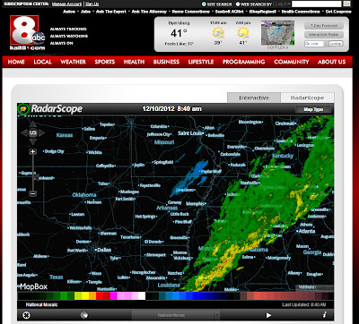
You can click the image above to enlarge it. Notice that this is a "National Mosaic" which is not a high resolution radar product. This product is used to see radar from a wider perspective as seen above. The box in the lower-center part of the screen shows what product you are seeing. To access high resolution, click the button shown below. This will give you access to Level 2 radar from various radar sites...
Once again, you can see what product you are using by checking the lower-center box. The default for Level 2 radar is Single-Site reflectivity. This simply shows you where it is raining, snowing, etc. You can zoom down to street-level and track the storms! If you click on the products available, you can click several products, including velocity data! This is the data that shows you what the winds are doing within storms. We show this quite often in tornado coverage! I clicked on a radar site in Mississippi to show you a storm that has a tornado warning this monring. The first image is a little busy because I have the "warnings" turned on from the "i" button. The second image is just velocity:
My point is... we are offering a ton of information for you, BUT you have to know the limitations. If there is a tornado event going on, we will be on air to explain it. If there is a winter storm, we will be on air to explain it. You can grab a laptop and follow along now!
So, what are your thoughts? Feel free to comment, leave Facebook comments, or tweet me. Feedback is encouraged!!! I'll try to answer any questions in another blog post.
Ryan


1 comment:
Thanks Ryan! You are the best weatherman. Not only do you keep us safe, now you are making us weather smart! We are blessed to have you here in Region 8.
Post a Comment