- Travel conditions deteriorate Thursday night and especially Friday.
- All modes of wintry precipitation are possible. Likely to go from rain to freezing rain... to sleet... and then to some snow.
- Right now, 0.50"-0.75" of glaze is possible with some sleet and snow on top of it.
- Worst case scenario would be more freezing rain than anything.
- Winter Storm Warnings and possibly Ice Storm Warnings are likely.
- A Winter Storm WATCH has already been issued for some areas to give advanced warning of what is going to happen on Thursday night and Friday.
- A second round of wintry mix will come in Saturday night. and Sunday AND is starting to look as impressive as the first round.
- Best case scenario (not likely) is to stay above 32 degrees and it be just rain. That might happen closer to I40.
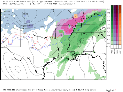
So, let's dig into some of the data. Nailing down the exact TYPE of precip for all of Region 8 is almost impossible, but if you are 32 or below at your house and liquid is falling instead of snow or sleet... it's the worst type. Here's the latest look at the data from the GFS model for Friday:
While this particular algorithm has us as sleet for a good part of Friday, I'm afraid that it will be more freezing rain than advertised. If most of it is sleet, we will be fortunate! Regardless, travel will be impacted across most of Region 8 on Friday. Let's fast forward to Sunday now...
Saturday night into Sunday is looking more concerning (above image). As a surface low passes to our south, it appears we may have more moisture than previously thought. I want to make sure that this second round does not sneak up on us! Once again, this could bring some MORE significant icing to Region 8.
Stay tuned as we adjust the forecast. There is still some time for adjustment.
Ryan


No comments:
Post a Comment