Notice in the above image that the heaviest rain will not extend too far from the center of the hurricane. This hurricane is not really large and will be moving fast. Excessive rainfall should not be an issue. Second landfall will come right before sunrise and radar could look like this:
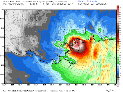
At this time, I would not be surprised to see some tornado warnings near Gulf Shores, Orange Beach, and Pensacola. The center is where the strongest winds will be located. These next two images show the projected winds at both possible landfalls. Remember, this is in KNOTS:
As you can see, the hurricane force winds will not extend too far from the center of the hurricane, but the Mississippi Coastline will likely see extensive damage. Thankfully, it's a category ONE hurricane and not stronger.
We will watch it closely, but it does not look to impact Region 8 too much.
Ryan


No comments:
Post a Comment