As you may have seen, the StormTEAM is specifically highlighting Tuesday and Wednesday this week. As we have mentioned, we are now making it easy for you to glance at the 7 Day Forecast to see the greatest threats to Region 8. It's our commitment to give you the FIRST WARNING of the possibilities of any watches, warnings, or advisories:
We have some showers and storms on radar this evening and we have some in the forecast for Monday. But, here are the reasons why we are a little more concerned about Tuesday and Wednesday:
- The WIND on Tuesday could have gusts up to 40 mph. This is not from thunderstorms, but from the pressure differences across Region 8.
- The RAIN on Tuesday night and Wednesday could prompt some flood watches.
- Rain totals for Tuesday night into Wednesday could be in the 1-3" range. (Not as high as some of the internet rumors out there, but still concerning)
- Heavy rain impacts farming, especially in early Spring.
While we are highlighting Tuesday and Wednesday, I don't want you to be overly worried about severe weather. The threat for hail and tornadoes is very low on these days.
Let me show you a few maps. First, let's talk about Tuesday's wind. The Euro and GFS models are showing possible gusts to 40 mph!:
Most of the rain holds off until Tuesday night. That's when some of the rain could be heavy. Here are the rainfall estimates from both models between now and Thursday. I think they are in pretty good agreement on amounts:
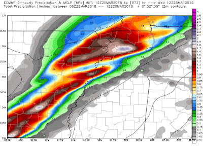
As I mentioned, most of the rain falls on Tuesday night into Wednesday morning. This is the European models outlook of rain amounts between 1AM and 7AM on Wednesday morning:
Plan accordingly and if there are any changes, we will be providing video updates on the Region 8 weather app and we will explain in deeper detail on TV. Have a great week.
Ryan


1 comment:
wah,, I wonder if thunderstorm will fall again in our areas
Post a Comment