- I'm confident it is going to snow over parts of Region 8 Wednesday night into Thursday morning.
- I'm also confident that it will melt quickly on Thursday, with temperatures going above 32°.
- Extreme NE Arkansas and SE Missouri have the best chance of decent accumulation.
- Big snowflakes
- Wet snow
- "Sticky" snow. This means that it should stick to the trees. I'm a little worried about trees that still have a lot of their leaves, like Bradford Pear trees.
- We will have the Central Nissan StormTRACKER out on Wednesday night and Thursday morning.
- We will be in the 50s on Friday.
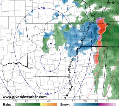
So, let's dive into the maps! I am starting to get a little more concerned about Wednesday evening. I know many of you have church plans and we may have the snow in some areas prior to the end of services. Here's what radar could look like at 6PM. The snow would be rotating in from the southeast:
As the sun goes down, this will start to accumulate in some spots. The storm team has gone over the latest data this morning and this is what we are thinking for snow totals by Thursday morning. Keep in mind that this forecast can change and we will be updating it through the storm:
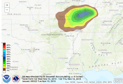
Let's talk probabilities. These maps from NOAA Weather Prediction Center breakdown accumulation by probability.
So, this map shows you the probability of seeing a 1" snowfall in Region 8. (About a 50% chance of a 1" snowfall for Jonesboro):
This shows the probability of seeing a 2" snowfall:
This shows the probability of seeing a 4" snowfall:
And because there is always a surprises with upper-level lows, here's the probability of 6" of snow. Yes, Poplar Bluff has a 10% chance:
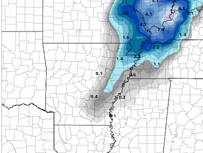
If you have stayed with me this far on the blog, let me also show you the raw numbers from the models. The probabilities match up well with the guidance of accumulations. Here are three models:
Stay tuned!!! This forecast may change.
Ryan


No comments:
Post a Comment