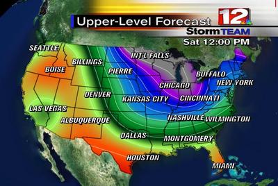
 Do you see that? Do you see the big trough (U-shaped thing) digging in from the North! We have an upper-level low diving North out of Canada later this week right on the tails of another upper-level low that will be a big weather-maker itself throughout the week. This big low will sit over the Great Lakes for a few days bringing spurts of clouds and reinforcing shots of cool air next week. (It's early in the season, but it looks a little like a polar vortex.) While our mornings have been cool the past few days, this weather pattern will make for cool afternoons as well. The reason we are seeing the cool mornings now is because the air is so dry, winds have been fairly weak, and we have had a clear sky. It's what we call radiational cooling. The afternoons have been very warm though! In fact, we could tie or break a record over the next few days! Not next week though! If you want to learn more about these nerdy maps (500 mb) click here.
For those of you that are not real interested in my colorful nerd map this morning and are more interested in seeing something funny, here's a video link to a reporter on The Today Show that made a situation look worse than what it was and got busted on LIVE television. Now I know why the media sometimes gets a bad name! Click here
One more nerdy note to pass along... The trough digging into the eastern part of the country is actually protecting us from HURRICANE Wilma (just upgraded as I typed this). Look at the forecast track and you can pickup on this as well!
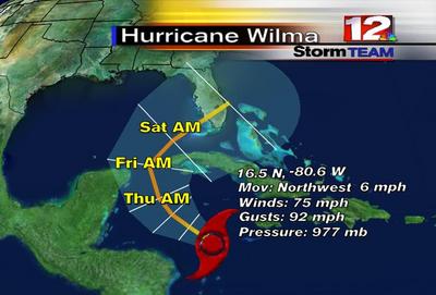
Here's a look at WSFA Storm TEAM 12 Hurricane Tracker. It takes the storm in Saturday Evening, somewhere between Ft. Myers and Tampa Bay. This is the last thing that any of us need, especially Florida.
![]()
Have a great Tuesday everyone!
Ryan
rvaughan@wsfa.com
No comments:
Post a Comment