 Let's talk about the dewpoints first (above image). I prefer to to see dewpoints over 55 to support any widespread severe weather. Our dewpoints are going to be riding somewhere between 55 and 62 when this weather rolls in Thursday... I would be more concerned IF the numbers were a little higher, but it still meets my personal criteria.
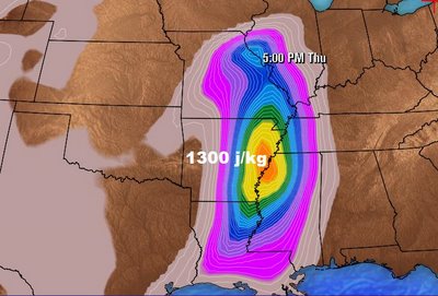
CAPE is another index we like to look at during these weather events (above image). The CAPE is the energy available to produce thunderstorms. CAPE peaks on Thursday at 1300 j/kg. We get concerned when it goes over 2000 j/kg. (joules per kilogram) As you can see, the CAPE is not all that impressive either. Just because the CAPE is low, does NOT mean we will not have severe weather. And that leads me to the dynamics of the storm....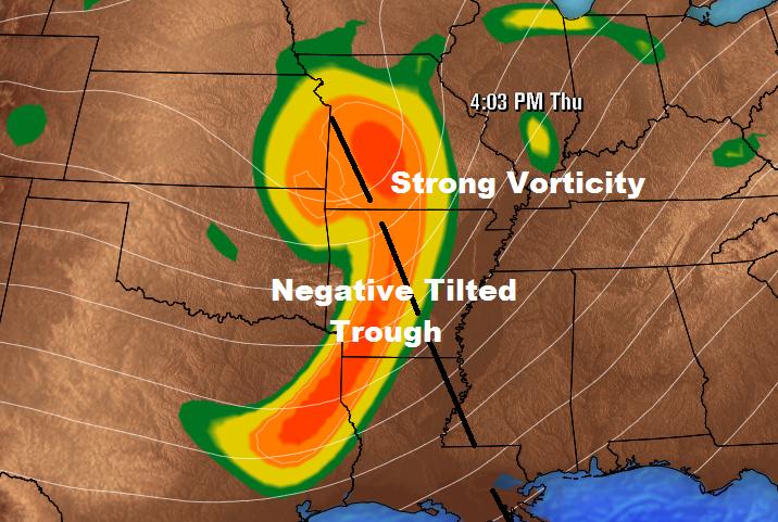 Here's where the storm gets impressive! As the upper-level trough approaches Region 8, it becomes negatively tilted. (above image) If you want to read more on what that means, check this link. The strong vorticity and negative tilt to the trough is a big red flag despite the lack of deep moisture and lack surface based CAPE. To read more about 500mb vorticity, click here.
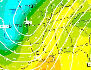 Finally, here's something else that makes my ears perk up like a German Short-Haired Pointer. The above image is the forecast of 850mb winds on Thursday. This shows winds at roughly 5, 000 feet blowing at 72+kts ! (80+ mph, 37 m/s) I get concerned when the winds blow over 40 knots at this level, so over 70 kts is another red flag!
In summary, the threat is there and if the instability becomes more impressive it could get nasty. We'll see...
Take care,
Ryan
rvaughan@kait8.com
No comments:
Post a Comment