- It is going to rain and it will negatively impact the agriculture community.
- Some people will get more than others.
- There is a chance of severe storms.
- The greatest threat for severe weather now appears to be Wednesday evening and night. MAybe Thursday, if the atmosphere recovers.
- We get a little break on Friday.
So, let's dive into some data. First, I heavily forecast using the Euro model. It's typically more stable and has a good history of being accurate. Here's how much rain it gives us through Saturday:
Generally speaking, it is giving most of Region 8 a good 1-3" area-wide, with some 3-6" in our southern counties. It's hard to argue with this model, given this setup. If this verified, parts of Poinsett and Cross counties would get the worst of it.
Another model that you will hear us use, is the GFS model. The GFS model also has our southern counties getting it the worst, but it has a SHARP gradient drop off as you move into our other counties of Region 8. It also has the heaviest rain from I40 southward:
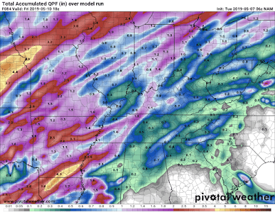
And now to one of our short range models. The NAM shows a solid 1-3":
Here's the deal. Some people are going to get over 4" of rainfall. We are going to have to watch how this storm evolves and unfolds. Pinpointing the exact location of the worst impact is almost impossible and really isn't going to to change anyone's preparation, at this point. We are going to be watching it closely, so stay tuned. I probably won't blog much more on this storm, so follow me on Twitter at @ryanvaughan and look for video updates on the Region 8 Weather App.
Ryan


No comments:
Post a Comment